


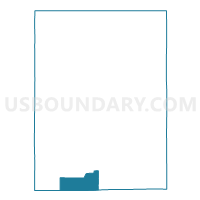
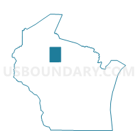
OGEMA - T 2 Voting District, Price County, Wisconsin
About
Outline

Summary
| Unique Area Identifier | 696345 |
| Name | OGEMA - T 2 Voting District |
| County | Price County |
| State | Wisconsin |
| Area (square miles) | 30.11 |
| Land Area (square miles) | 30.11 |
| Water Area (square miles) | 0.00 |
| % of Land Area | 100.00 |
| % of Water Area | 0.00 |
| Latitude of the Internal Point | 45.40271970 |
| Longtitude of the Internal Point | -90.45618610 |
Maps

Graphs
Select a template below for downloading or customizing gragh for OGEMA - T 2 Voting District, Price County, Wisconsin


Neighbors
Neighoring Voting District (by Name) Neighboring Voting District on the Map
- CATAWBA - T 1 Voting District, Price County, WI
- KENNAN - T 1 Voting District, Price County, WI
- OGEMA - T 1 Voting District, Price County, WI
- WESTBORO - T 1 Voting District, Taylor County, WI
Top 10 Neighboring County Subdivision (by Population) Neighboring County Subdivision on the Map
- Ogema town, Price County, WI (713)
- Westboro town, Taylor County, WI (684)
- Kennan town, Price County, WI (356)
- Catawba town, Price County, WI (269)
Top 10 Neighboring Unified School District (by Population) Neighboring Unified School District on the Map
- Phillips School District, WI (6,041)
- Prentice School District, WI (2,966)
- Rib Lake School District, WI (2,673)